


The knowledge and art of cartography is visualized in an immersive way in 3D
British Geological Survey, Virtalis y Christie están ayudando a los científicos a ver el mundo de otra forma, en concreto en tres dimensiones, cuando visualizan las complejas estructuras, detalles y formaciones geológicas que conforman nuestro planeta a la hora de trazar e interpretar un mapa y así comprender mejor su funcionamiento, recursos y amenazas existentes debido al crecimiento de la población y al cambio climático.
¿Cómo mostrar en dos dimensiones un mundo tridimensional? Este es uno de los retos a los que siempre se enfrentan los técnicos y expertos para trazar en un mapa las complejas estructuras y formaciones que componen el planeta.
Los mapas geológicos se utilizan para calcular posibles amenazas sísmicas, predecir inundaciones o informar sobre cómo el hombre puede defenderse frente a ellas, si bien su uso también ha permitido desde encontrar minerales valiosos, a realizar prospecciones o acumular un completo historial de fósiles para mejorar el conocimiento.
In this sense, los científicos del British Geological Survey (BGS) son autores del primer mapa completo de las reservas de agua de África. Pese a estos logros cartográficos, geólogos, topógrafos, etc. han de convertir en sus mentes la imagen bidimensional del papel en otra tridimensional, algo que no resulta sencillo de hacer y menos de reproducir.
To respond to this challenge, los responsables del BGS se han propuesto encontrar la solución idónea para convertir la actual cartografía 2D en imágenes tridimensionales en la próxima década. Una evolución que tiene ha tenido un claro impacto en estos profesionales al conocer el sistema de visualización StereoWorks de Virtalis, un referente en realidad virtual.
Así lo explica el doctor Martin Smith, jefe de la estación de BGS en Edimburgo: “la realidad virtual elimina la necesidad de pasar de 3D a 2D y de nuevo a 3D. Now, los miembros del equipo de un proyecto pueden construir juntos un modelo tridimensional, interactuar con los datos e interpretarlos en grupo”.
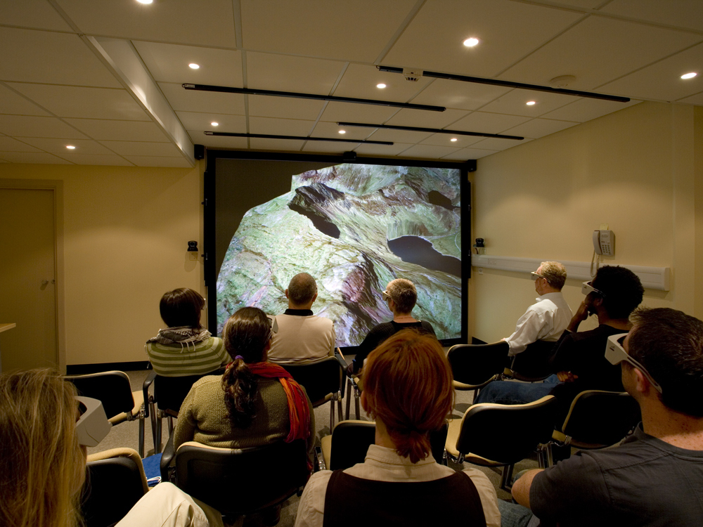
For this, Virtalis ha incorporado a su sistema integrado de visualización StereoWorks el proyector Mirage S+4K de Christie, que utilizan desde hace tiempo, en la sede central de BGS en Nottingham; una instalación que han replicado en la delegación regional de Edimburgo, y cuyo éxito en ambos casos ha animado a esta compañía para que se actualice a un entorno de modelado 3D completo, lo que exigía un paquete de software de este fabricante y la seguridad de que el sistema Mirage S+4K podría proyectar estéreo activo de grado alto en una pantalla de 3,1×2,3 metros.
Experiencia colaborativa
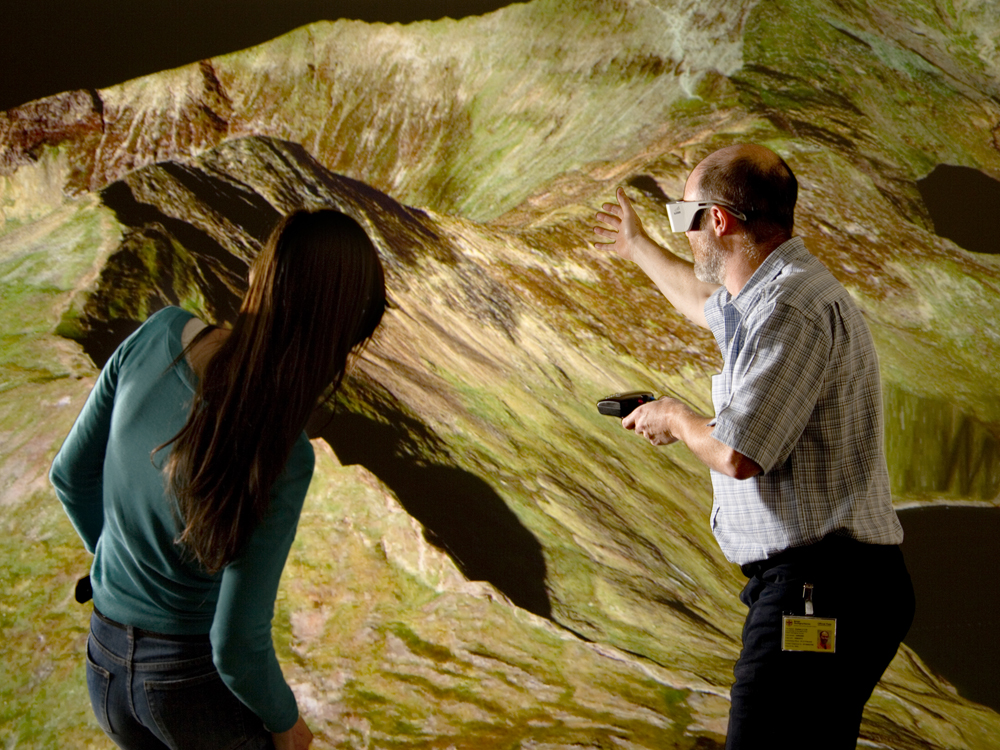
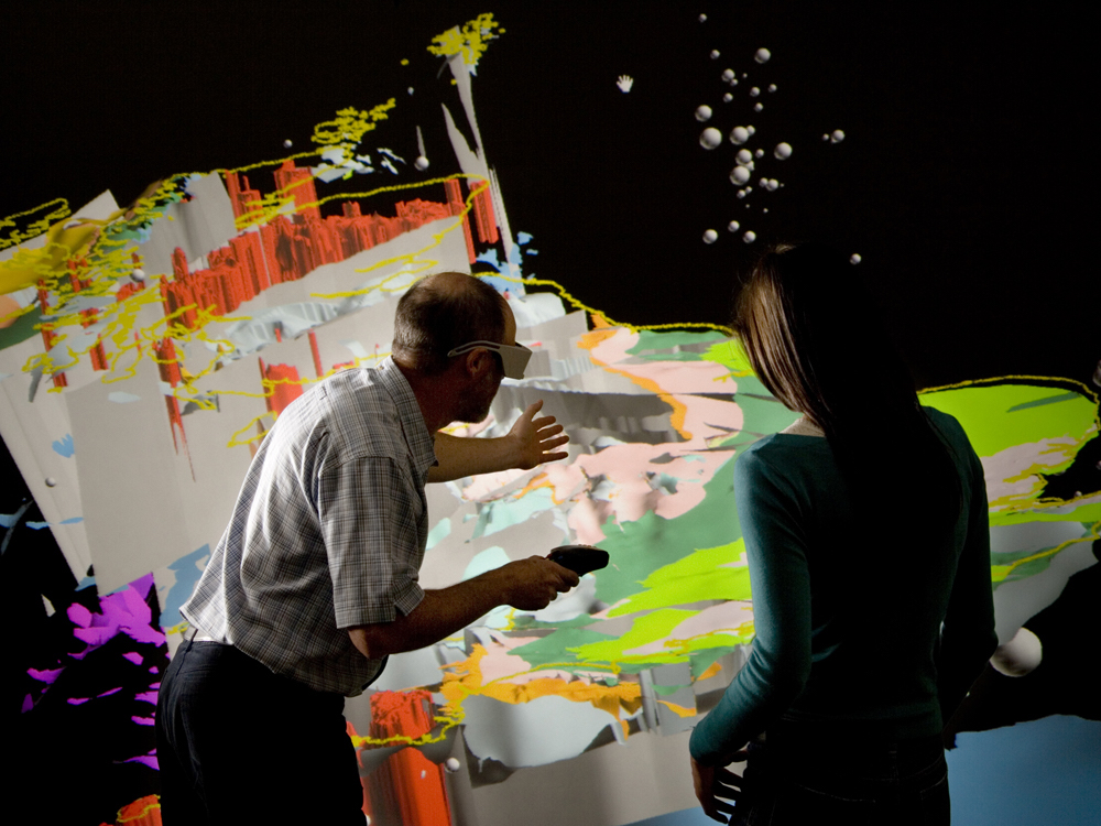
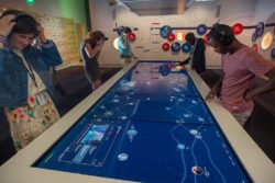
Como explica Andrew Connell, director técnico de Virtalis, para este entorno 3D el proyector Christie Mirage tenía muchas bazas a su favor, ya que “esta herramienta permite a los geólogos presentar sus descubrimientos de manera atractiva y participativa; responde con eficacia a los movimientos de la cabeza y las manos facilitando con ello un display estéreo auténticamente inmersivo”.
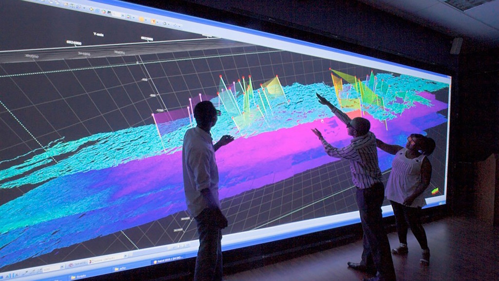
Besides, el ancho de banda de 220 MHz del Mirage permite que la imagen reaccione instantáneamente a la posición de la cabeza del usuario, provocando así un efecto holográfico y una inmersión de los geólogos en el paisaje. Capaces de leer datos del modelo (estratos, epicentro y magnitud de un terremoto, imágenes geoespecíficas o datos convencionales), las diversas imágenes pueden fundirse con la topografía base, y las imágenes de satélite con mapas políticos, cambiando luego a datos geológicos codificados cromáticamente.
Aunque esta experiencia inmersiva y colaborativa puede presentarse en una sala de veinte butacas, para el Dr. Stuart Clarke, geólogo topógrafo de BGS y responsable del desarrollo de muchos de los modelos 3D, funciona mucho mejor cuando equipos de cinco o seis miembros trabajan cerca de las imágenes de alta resolución y “gracias a la inmersión total, aprovechan al máximo el efecto 3D estéreo”.
Antes de encontrar esta solución “girábamos modelos en la pantalla -puntualiza Clarke-; pero en una plana las imágenes 3D a menudo llevan a confusión por la posibilidad de que el cerebro las malinterprete como consecuencia de las trampas habituales en la visualización. El estéreo ofrece la posibilidad de visualizar los modelos con la perspectiva correcta”.
Did you like this article?
Subscribe to our NEWSLETTER and you won't miss anything.
Related articles
 Sony envisions Stella McCartney's show at Paris Fashion Week
 PPDS connects art and sustainable technology in the 'Muse Digital Art Prize'
 Dirty Monitor creates an immersive art gallery with the work of Claude Monet
 Extron AV Technology Facilitates the Dissemination of Medical Knowledge at UNC
 Igloo Vision promotes 360º knowledge and collaboration at the NBI
 L-Acoustics L-ISA offers a 360º immersive experience for an art exhibition
 ClearOne views BMA microphone coverage 360 con Autodesk Revit
 HoloDicom visualizes DICOM images as 3D holograms in a real environment
 Grammy Museum Visualizes Music History with Planar 4K Screens and Video Wall
 VRPolis will recreate in an immersive way what Santander will be like in 2100 at the London Design Biennale
 The Rugby World Cup 2015 is displayed on the Daktronics Led screens
 The Eizo CG248-4K monitor displays 4K images in great detail
 Crystal Display Systems' square LCD screen displayed in ISE 2015
Samsung and Miguel Chevalier create immersive and sensorial digital artwork ‘Origin of the Curve’ for IFA 2014
Crystal Display Systems' square LCD screen displayed in ISE 2015
Samsung and Miguel Chevalier create immersive and sensorial digital artwork ‘Origin of the Curve’ for IFA 2014